Tues - Off
Weds - Off
Thurs - 8 miles (1,800') easy. Ran the Towers TT at a very moderate effort to the halfway, then picked up the pace just a notch as I started to warm up. 35 and change, I think. Descent was a little sore on my right hip, and legs in general, but nonetheless things are looking good for a speedy Leadville recovery.
Fri - 9.5 miles (3,000') easy. Round Mountain. Met Steph and Mary at the Round TH for a late afternoon run to the summit. Half a mile in, Steph and I stopped in our tracks 15 meters behind a big 200 pound bear who was sauntering down the trail. Bear heard Steph pull up, looked back and then casually headed up the hillside. By the time Mary caught up, the bear was a good 50 feet above us and we carried on our way. Second bear sighting in the last two outings on Round. Always a bonus. Bears aside, the moderate-effort ascent (57:05) felt descent, while the descent was just okay, but noticeably better than yesterday on Towers.
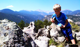
Sat - 3.5 miles (800') hike. Ranked Peak 8,194' - aka 'Giant Boulder Point.' Had plans to scout the tricky 5.7 west ridge of Pagoda with Brian, but he bailed the night before with a sore knee, so I enjoyed a fun little hike with the family instead. It's been a while since I checked in with the Larimer County high points project, so I decided to bag a nice easy one as part of our hike. The start point for this hike is off the Devil's Gulch Road past Glen Haven and just before the first of the two big S-bends that take you to the plateau above Estes. As described by Joe Grim on the Lists of John site, you essentially head under the three powerline transformers on the north side of the road (parking at a pull-off on the south side), following an old dirt road for 20-30 meters before picking up a faint trail to the left. We followed the trail for probably a mile or so, before cutting cross country up a drainage. Dana and Stella hung out in a nice spot on the ridge, while Alistair and I ran west along the ridge tagging two bumps along the way until we hit the actual summit block. Gaining the top of the summit rock requires some class III climbing, which was a lot of fun for Alistair, but really quite straightforward. The views from the top were exceptional for such a lowly peak. Longs was framed beautifully by a hole in the ridgeline to the south, while the Mummy's and more were impressively clear to the north and west. After a couple of summit shots, and signing in on the Lists of John member-studded log book, Alistair and I boogied back to the girls, packed up their picnic and made quick work of the exit, stopping for delicious cinnamon buns at the 100-year-old Glen Haven general store on our way down the canyon. Fun morning.
 | |||||
| Ranked Peak 8,194'. Photo: Brandon Reich (from Lists of John). |


Sun - 6 miles (2,800') peak baggin'. 8,310' & 7,567'. Enthused by yesterday's outing, I decided to pick up a few more of Larimer County's 255 ranked peaks, focusing again on the Big Thompson area. I had meant to knock off 8,092' with the other two this morning, but as is often the case with these bushwhacking routes, things frequently move much slower than planned. Anyway, with these two picked off, I only have two of 10 peaks left to bag in the Drake quadrangle: 8,092' and Pole Hill.
To get on 8,310', I drove about two miles up the tight Waltonia Road south off Hwy 34 to approximately 6,900' where the road dead ends at a private gate. I parked there and then ducked under the gate before heading in a southeasterly direction straight up the hillside, crossing one drainage and then following another to the ridge. There was some fun class three/four rock moves to be made approaching the ridge. Once on the ridge, the grade mellowed out and it was an easy, grassy jog to the rock pile at the summit. To my surprise, there was a pill box summit register at the top, which described the summit as 8,240'. This had me confused, especially as I could find nothing on the map suggesting an 8,240' peak in the vicinity. I'm 99% certain that I was on 8,310' as intended. After figuring the lay of the land on the south side of Round Mountain, I proceeded in a southeasterly direction for unranked point 7,812' along the ridge that forms the south side of a valley with the Round Mountain ridge to the north. From 7,812' I dropped down to Saddle Notch, following an old undeveloped homesite road to the road that services a couple of impressive houses down in the Round Mtn Saddle Notch Valley. Then it was just a question of crossing the road and hoofing the 400 or 500 feet up to 7,567'. No summit register that I could find, but there was a definitive summit rock pile. I essentially backtracked the way I had come, deciding to leave 8,092' for another day due to time constraints, which was a bummer, but my fault for being lazy and not getting up earlier. Just 210 more ranked Larimer summits to tag!
Total: 27 miles (8,400')
Nice easy week finding my legs after Leadville. It was good to be back ticking off peaks in the Larmier County project. I look forward to really getting back into that once I'm done with UROC. I'm also looking forward to taking a stab at the Glacier Gorge Traverse next weekend, but am a little nervous about the Pagoda west ridge section from Chiefs Head. That section will have to be a game-time decision for me as I've never seen it before, but all indications suggest that there's no avoiding a couple of very airy 5.6/.7 crux sections, without dropping all the way down and re-climbing.


.png)


how was the Leadville 100 for you? Were you happy with your effort put forth?
ReplyDelete