Week Ending August 3
Mon - 6 miles easy (500'). Felt a little off today, so just jogged things out on the Valley Loop to Arthurs from Soderberg.
Tues - AM: 5 miles (1,500') easy. Jogged an easy lap of Horsetooth.
PM: 6.5 miles track. Workout was 1,200 open followed by 12 x 300 relay repeats w/100 jog between each interval. I came in with the intention of taking these easy, but predictably enough started getting competitive as the workout went on and the back and forth between me and Sarah, and Lee and Garcia starting playing out. Sarah would lose ground to Garcia and then I would pick it back up against a slowing Lee. Came down to the final rep, where I was able to out-lean Lee into the finish. Fun stuff, but I tweaked my knee in the process. Doh.
Weds - Off. Gave my knee the day off after overextending it at the track.
Thurs - AM: 10 miles (1,400') moderate hill tempo. I had wanted to get a good tempo done on Centennial Rd this morning, but I played it safe with my knee and decided to up the return tempo just moderately.
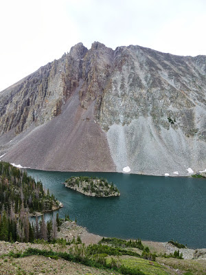
PM - 5 miles (1,500') easy. After heavy rains, the Soderberg trailhead was closed to foot traffic so we relocated the biweekly Towers Time Trial to the upper lot for a go at Horsetooth. Still concerned about my knee, I invited Alistair out to join the group to see if he could better his Horsetooth PR of 45:30. He seemed pretty motivated, so we got after it from the gun and he tore up the mountain in 39:37 for a huge six minute PR. It was super fun to watch Alistair run with a group like this. Adding to the fun, we saw a bear on the way back down, before Alistair let rip dropping me and my dodgy knee in the process.
 |
| Horsetooth TT group. PR for Alistair. |
 |
| Bear sighting on the way back down. |
Fri - 7 miles (1,800') easy. Jogged out a nice easy Horsetooth to test the knee and things felt good.
Sat - 6 miles (2,500') hiking and bagging. Drove up to Cameron Pass with Abby Saturday afternoon in preparation for a tour of the
Never Summer route on Sunday. With the late start, we kept things reasonably short and accessible. Starting at the Cameron Pass parking lot, we headed out on the Ditch Trail for just a half mile before bushwhacking steeply for Table Iron Mountain (12,060'). Breaking above the trees, the craggy and cliffy west face looked intimidating, but we were able to negotiate to the north with little difficulty. As the name suggests, the top was flat and red. From Table Iron it was a simple traverse over to Iron Mountain (12,265'), from whence we dropped back down to the saddle and then dropped back to the Ditch by way of a couple of steep, wildflower-chocked drainages. Fun route.
 |
| Richthofen, Static Peak and the Nokhu Crags (12,485') from Iron Mountain (12,265'), with 'The Electrode' as the high point on the ridge leading to Static between Richto and the Crags. |
 |
| Abby on the Iron Mountain descent |
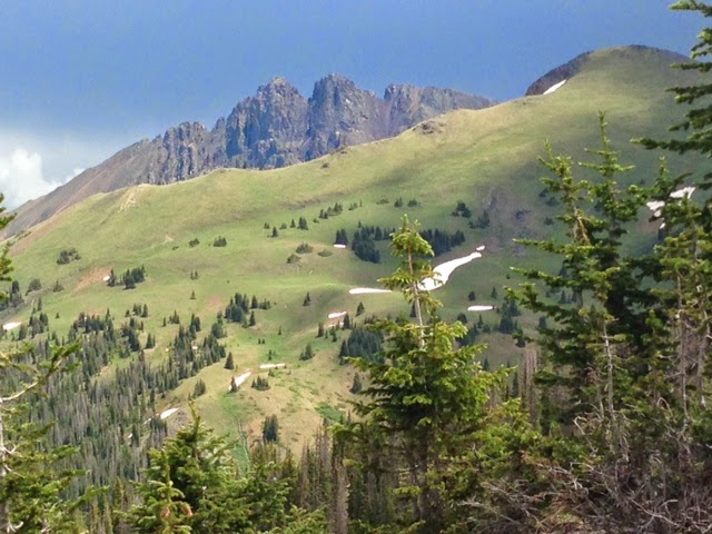
Sun - 46.5 miles (10,500') long. The original intention for the morning was to run the full Never Summer 100km loop, but I ended up cutting it short at 46 miles due to the route being a little more taxing than expected (and because I had a convenient bail-out option). The morning began with a beautiful early ascent of Seven Utes Mountain (11,453') from the Gould Community Center and a fantastic contour and descent into the serene and uber-picturesque Lake Agnes (10,663') at mile ~11. Pete and I have been bashing around these parts all summer and finally figured a great route into Agnes the weekend before on an old logging road. It pops out right at the cove (after some light bushwhacking), leaving a nice section of trail around the lake to get on the Ditch Trail. It was my first time on the next section up to and around the American Lakes and I have to say I was blown away at how stunning the bowl up there behind the Nokhu Crags is. This really is going to be a phenomenal race course.
After a crewing snafu at Cameron Pass (and a 25 minute wait), I headed up North Diamond Peak (11,852' and high point on the course) at a strong push and enjoyed an almost windless ride along the carpet that is the Medicine Bow Ridge to the Montgomery Pass 4 x 4 road, enjoying more incredible views in the process. After bashing across the Yurt contour trail, I met up with Cam at Ruby Jewel Rd to knock out the stunning high alpine Hidden Valley section of the course, which at 10 slow miles is probably the crux of the route. I started bonking a bit on the descent off Kelly Lake and then really hit the wall heading up to the Clear Lake Spur, where Pete and Karla were waiting with water. Although I wanted to bail there, I forged on and ground my way up to Clear Lake (10,600') where I sat for quite some time, perched scenically under South Rawah Peak, trying to collect myself. On the descent I made the decision to bail so took the short way back to the northern trailhead meeting back up with Pete and Karla, followed two minutes later by Abby who had somehow managed to run a marathon while totally lost in the woods (long story). All in all, this was a fun morning, but man did I ever get my arse handed to me? This is a tough course.
 |
| Crags early morning from the west near top of Seven Utes. |
 |
| Crags a couple hours later from American Lakes on the east side. |
 |
| The carpet ride on the Medicine Bow ridge. North Diamond (11,852') is the high point at the end of the ridge and the high point on the Never Summer 100km course. |
 |
| Overlooking Kelly Lake (10,805') in the Hidden Valley section of the course under the Medicine Bow Mountains. |
 |
| One of three moose sightings on the morning. Saw a flock (?) of big horn sheep at Kelly Lake too. |
Total: 92 miles (19,700')
Week Ending August 10
Mon - 6 miles easy. Jogged out some recovery mileage on the valley trails.
Tues - AM: 4 miles on the mill. Ran for half an hour on the mill at the Parker Lifetime Fitness where Abby works to conduct some metabolic testing. Ran at 100 mile effort with a contraption strapped to my face. The results show that my body is quite fat efficient, meaning that I burn mainly fat while at 100-mile effort and my calorie intake need only be in the 100 calorie per hour zone. This means I have been consuming way too many calories in the past, which may account for my stomach issues in recent races. Anyway, Abby and I are taking the information from this test and working on a nutrition plan for Steamboat. Fingers crossed.
PM: 6 miles track. Workout was 1,200 open, the 8 x 400'. Again, tried to keep these under control to stave off any potential knee issues, but got a bit racy towards the end and re-tweeked the knee.
Weds - 7 miles (1,800') super easy. Jog/hiked a summit of Horsetooth, babying my strapped knee in the process. Felt okay.
Thurs - 5 miles (1,000') easy. Drove out early to Salt Lake City to attend the Outdoor Retailer show with Altra. Got in around noon and headed out to Red Buttes for a few miles on the spiderweb out there.
Fri - AM: 6 miles (1,200') easy. Jogged up to the 'living room' with Zac Marion and Zach Bitter from where we enjoyed the killer views of the Salt Lake Valley and Cottonwood Canyons.
PM: 3 miles with 1.6 miles at 15% on the treadmill over the course of 15 minutes. I never run on the treadmill, but the OR uphill challenge marked my second visit to the mill of the week. Somewhat out of shape, I was predictably worked by this exercise in pain, cutting my speed as the run progressed. Paired up with Bronco Billy, we ended up in a dead heat. Major sweat fest.
 |
| Warming up with Jeff Browning before setting it at 15%. |
Sat - 15 miles (2,500') easy. Super early start from the Upper Big Water trailhead with a bunch of Altra athletes for a super-fun tour of the Lake Desolation area of the Wasatch 100 course. It was so cool to see this area at a different time of day and while not completely exhausted. The Wasatch are just burly, burly mountains and I love getting up in 'em. Got some great beta from Craig Lloyd on some of the link-up opportunities in and around the area: one day.
Credit: trailandultrarunning.com
Sun - 21 miles (5,000') easy. Back home and strapped for time, I ran locally at Horsetooth and Lory, completing the classic double summit of Horsetooth and Arthurs. Been a while since I ran long on the home trails, so I was extra appreciative of the fantastic access that I have and which I typically take so much for granted.
Total: 73 miles (13,000')
Week Ending August 17
Mon - 7 miles (1,800') easy. Jogged out a nice easy summit of Horsetooth with John and Adam from Minnesota, who were on their way to Leadville to crew and pace my good friend Bob Gerenz who was getting ready to take his third crack at the classic 100 miler. About an hour PR for Bob as it turned out.
Tues - 12 miles (4,000') easy. A nice light day at Rocky Mountain National Park with my good friends Takashi and Masa from Japan, both of whom helped crew me at Mout Fuji earlier in the year. Did the classic Flattop, Hallet, Otis and Andrews Glacier loop, while photo-shooting some stuff for a new apparel brand - Teton Bros - that Takashi has launched with a couple of partners in Japan. Tacked on East Glacier Knob at the end. Beautiful weather and just a fun, fun loop.
 |
| Cruising around the Andrew's Galcier tarn. |
 |
| Glissade! |
 |
| The new Lone Peak 2.0s are pretty sweet |
 |
| Scrambling up Otis |
 |
| Me and Takashi heading down Otis on our way to Andrews Galcier. |
PM: 3 miles at the track. This was an emotional evening at the track, as we were there primarily to dedicate a beautiful bench to one of my biggest running inspirations, Jane Welzel. Workout was: 1,000 open, followed by a light 8 x 200, with runners sharpening for the Mountain Avenue Mile on Thursday. Took things nice and easy.
 |
| On the Quada, Quada bench with the incomparable Jane Welzel. |
Weds - 7 miles (1,800') easy. Casual jaunt up the Tooth (133).
Thurs - 8 miles easy and hard. Jogged out a few miles on the Blue Sky trail on my way into town, then ran a couple of laps on Mountain Avenue for the Mountain Avenue Mile. First up was the kids' race, where I paced Alistair to a 7:09 finish, then it was time for Beauty and the Beast (old farts) where I got a read on just how unfit I am currently, not even able to breach 5 minutes (5:07 - 73, 78, 78, 78); Oovay.
Friday - 5 miles (2,000') hike. Up in Leadville to pace a couple people the next day, I hooked up with Abby to go bag Sheridan (13,748') before heading back into town to discuss pacing/crewing plans with Tony Stafford and then Mike Aish.
Saturday - 38 miles (~6,000') pacing at Leadville. Picked up Mike at Winfield and was pleasantly surprised at how well he ran the contour trail over to the base of Hope Pass. The climb up Hope was pretty good, although Mike started slowing significantly towards the top, and then markedly on the descent. He was complaining of sore knees and was moving really slow. Rob Krar went through a quarter of the way down and then Ian passed on the meadows into Twin Lakes - a 20 minute lead evaporated. I really thought Mike was done and buried, but after a quick shoe and sock change he was out of there. I dilly dallied getting stuff I needed and it took me a half mile to catch back up to Mike who, to my surprise, was marching up the hill to the Elbert TH with conviction. Once we hit the high point at the Elbert trailhead, Mike really started building a head of steam and by the forest roads he was really rolling to the point that I was now concerned he was moving too fast. I kept my mouth shut and we were soon passing a surprised Ian, putting mileage on him very quickly. Mike would stay on the gas until near the new field section into Outward Bound, where he suddenly pronounced a need to walk. Ughh, followed shortly thereafter by a gut emptying session in the meadow. I left him at Outward Bound thinking he was in trouble, but to his immense credit he rallied to the finish knocking out a hugely impressive 1:49 from May Queen to the finish for second overall, and easily the fastest closing split ever recorded.
 |
| Breaking above the trees on Hope with Missouri Mountain behind. |
 |
| Rolling with less than 30 miles to go. |
Part two of my pacing gig came around four or five hours later. Tony was in a bit of trouble when I picked him up at Outward Bound as he just wasn't able to get calories in. The march up Powerline was slow, but we got there eventually. I ended up banging my toe pretty good on the Colorado Trail section so had to pull the plug at May Queen handing Tony off to Jim for the trudge through the night. Despite his troubles, and to his immense credit, Tony still finished in a respectable sub 26 hours on his first go at the distance. He'll be back to get that big buckle next year.
On a side note, I have nothing but positive things to say about the race management this year. Clearly, those involved listened to the bitching from last year and got it spot on in 2014. Very well done!
Sunday - Off. after 45 minutes of sleep I headed home early enough to beat the traffic. I wanted to get out and hike with the kids, but Alistair nixed all and any hiking plans so we went into town and got ice cream instead.
Total: 80 miles (15,600')
It's been a very busy August, so I'm getting the mileage in where and when I can for Steamboat. I feel like I have a good nutrition plan figured out with Abby for the race, so I am hopeful that with an agreeable stomach I can more than make up for my current lack of fitness and register a decent finish. Time will tell on that.

 Start times are 7:00, 8:00 & 9:00, so pick a time and a distance that is likely to get you back in good time for the after party at my house.


.png)

