Mon - AM: 7.5 miles easy. Giles Lane - Tyler Hill - C&W - Park Wood - Station West.
PM: 3 miles easy. 2 x uni loop. Wet and windy (what a surprise).
---------------------------------------------------------------------------
2012 BY THE NUMBERS
January: 330 miles (45,200')
February: 445 miles (58,500')
March: 501.5 (79,600')
April: 430 (66,800')
May: 387.5 (70,700')
June: 297.5 (48,500')
July: 369 (71,100')
August: 330.5 (67,100')
September: 344 (65,000')
October: 211.5 (48,400')
November: 227 (55,400')
December: 245 (38,300')
2012 Total: 4,118.5 (714,600')
2011 Total: 4,264 (729,400')
2010 Total: 4,100 (655,850')
2009 Total: 3,451 (486,600')
2012 Avg: 343 miles (59,550')
---------------------------------------------------------------------------
2012 Summits (241):
.......................................
Horsetooth (7,255') (105)
.......................................
Mount Elbert (14,443')
Longs Peak (2) (14,259')
Mount Belford (2) (14,197')
Mount Oxford (14,153')
Missouri Mountain (14,067')
---------------
7 x 14ers
---------------
Pacific Peak (13,950')
Emerald Peak (13,904')
Crystal Peak (13,852')
Atlantic Peak (13,841')
Iowa Peak (13,831')
Hagues Peak (2) (13,571')
Ypsilon Mountain (13,514')
Fairchild Mountain (13,502')
Mummy Mountain (13,425')
McHenrys Peak (13,327')
Pecks Peak (13,277')
Whitney Peak (13,271')
Powell Peak (13,208')
Taylor Peak (13,153')
Mount Chiquita (13,069')
----------------
16 x 13ers
----------------
West Mount Sheridan (12,952')
East Desolation Peak (12,949')
Julian (12,928')
Stones Peak (12,922')
West Desolation Peak (12,918')
Mount Ida (12,880')
Point 12,820' (Chorier Point)
Chief Cheley (12,804')
Cracktop (12,766')
Terra Tomah (12,718')
Hallet Peak (12,713')
Otis Peak (12,486')
Mount Chapin (12,454')
Flattop Mtn (12,324')
Marmot Point W(12,005')
-----------------
15 x 12ers
-----------------
Marmot Point E (11,909')
Twin Sisters (11,420')
Mount Baldy (11,068')
Estes Cone (11,006')
-----------------
4 x 11ers
-----------------
Hidden Peak (10,992') (2)
Dark Mountain (10,859')
Lookout Mountain (10,626')
McGregor Mtn (10,486')
Needles (10,086')
10,008'
-----------------
7 x 10ers
-----------------
Storm Mountain (9,918')
Pierson Mtn (9,803')
Lily Mountain (9,786')
Lion Head (9,740')
Rams Horn (9,556')
9,540'
9,495'
9,475'
Kruger Rock (9,355')
9,342'
Panorama (9,284')
Crosier Mountain (9,250') (4)
Emerald Mtn (9,237')
Gem Peak (9,140')
Giantrack (9,091')
--------------------
18 x 9ers
--------------------
Sugarloaf Mtn (8,980')
Eagle Cliff (8,906')
Prospect Mountain (8,900')
Castle (8,834')
Pilot Hill (8,829')
8,820'
Mount Olympus (8,808')
Pole Hill (8,603')
Mount Ethel (8,471')
8,415' (Leila Peak)
Triangle Mountain (8,415')
8,380'
8,380'
Buckhorn Mountain (8,341')
8,310'
Round Mountain (8,250') (4)
Palisade Mountain (8,225')
8,194' (Giant Boulder Point)
Alexander Mountain (8,144')
8,092'
-----------------------
23 x 8ers
-----------------------
Blue Mountain (7,888')
Spruce Mountain (7,781')
7,814'
Sullivan Stump (7,778')
Turkey Roost (7,734')
7,725'
7,660'
7,655'
7,620'
7,567'
7,509'
7,500'
7,470'
Green Ridge (7,402')
7,383'
Green Mountain (7,335')
7,260' (Ziggy Point)
7,220'
7,178'
7,135'
Red Mountain (7,105')
7,098' (Poll Mtn range)
Table Mountain (7,074')
------------------------
128 x 7ers (incl 105 Horsetooth summits)
------------------------
6,930'
Arthurs Rock (6,780') (6)
Milner Mountain (6,893')
6,674'
6,300'
6,227'
6,100'
------------------------
12 x 6ers
------------------------
Morril Benchmark (5,791')
5,773' or 'Aggie Peak'
5,740' (Hwy 34 B4 Narrows) (1)
5,740' (Off Masonville Rd) (2)
Reservoir Ridge (5,735')
Goat Hill (5,604')
------------------------
6 x 5ers
------------------------
Aitxuri (1,551 meters)
Aizkorri (1,528 meters)
Aratz (1,443 meters)
----------------------------------------------------------------------------
Tues - AM: 10.5 miles (500') w/5k race (17:09, 1st). My fourth and final parkrun race of the UK visit in the company of 7 other Clarks, no less. Ran over to Whitstable from Canterbury, picked up my old mate Jim along the way and then learned that we were going to be running an all pavement version of the course this time around due to the super soggy underfoot conditions on the Tankerton Slopes. From the off, I slotted in behind the same young lad who'd led out the run on Christmas Day and let him set the pace for much of the first lap (8:25). I led the second lap and felt myself fading up the hill and into the wind on the final kilometer and a half. Thought I might sneak under 17, but came up a bit short. Doubled back once I was done to catch up with Alistair. He ran in for a six minute PR (29:37).
 |
| Karen |
 |
| Matt |
 |
| Alistair |
 |
| Me |
 |
| Maddie |
 |
| William |
 |
| Thomas |
 |
| Dana |
PM: 3.5 miles easy. 2 x uni loop w/around the block add on.
Thurs - AM: 10 miles (500') easy. To Chestfield and back on the Crab and Winkle with Anthony, a local runner who'll be running his first 100 miler this summer. Anthony has been following the ultra scene for a few years now and it was interesting to hear his take on UK ultrarunning. By all accounts, the sport is currently exploding in popularity much the same way as it has been in the U.S. over the last decade. I was excited to hear that Anthony will be running the North Downs 100 this summer, which is about as local a 100-miler as there is in the UK to my home town of Canterbury. It runs point to point from Farnham in Surrey to Wye in Kent on the North Downs Way, a long distance hiking trail, stopping just short of Canterbury. The route passes through bucolically scenic terrain over gradually rolling hills, and I would highly recommend the route to anyone considering an ultra in the UK. I was actually planning on doing the Canterbury loop of the North Downs Way on my visit, but given the current ground saturation, the 45 mile route through farmers' fields and the like would have been more misery than fun, unfortunately.
 |
| Me and Anthony outside my parents house. |
Fri - Off. Flying back to Colorado.
Sat - AM: 20 miles (1,800') easy w/ Mike, Slush and Sarah. It was good to reconnect with friends on my first run back in Colorado. We ran from my house down to Redstone Canyon, which we out-and-backed before finishing up with a loop of Milner Mtn and a few tack-ons at the end to hit the magical 20 mile mark. Toe-numbingly cold before the sun hit the canyon, but just a beautiful morning once it warmed up.
Sun - 9 miles easy on the bike paths setting up the Edora Park 8k T&H course, among other things. Still jetlagged, I was up at 4:00 am and ready to go, so I headed out the door and got a run in. It was incredibly cold in the dark (my car said 2 degrees), but with no wind and minimal humidity it was fine once the internal furnace kicked in. Standing around registering runners for the race was a different story, however. Brrr.
Total: 70 miles (2,800')
Looking at the 2012 numbers, it is (vaguely) interesting to see that I posted essentially the same yearly mileage and vertical total as in 2011 and 2010, despite the low 200-mile months through the last three months of the year. I'm a big believer in consistency over the long haul and those numbers state just that. With a mellow October through December, I feel like I'm ready to harness that three-year base and really get after it in 2013; maybe my last serious year of running and racing before looking at different ways of utilizing my energy in future years.
In other news, I'm going to be running on the island of Ometepe in Nicaragua next month for the Fuego Y Agua 100 km race. I'm excited to say the least. Ometepe is a volcanic island in Lake Nicaragua, an inland freshwater lake, with not one but two volcanoes, the higher of which - Concepcion - is still active. The course - which takes in both summits - looks incredibly challenging and fantastically scenic. I'm counting my blessings.
| Ometepe Island |
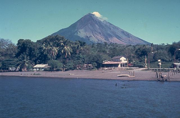 |
| Volcan Concepcion |
 |
| Volcan Madera |


.png)


"maybe my last serious year of running and racing before looking at different ways of utilizing my energy in future years."
ReplyDeleteThat's a big statement, Nick. I'm hoping you have a great 2013!
Wyatt
"maybe my last serious year of running and racing before looking at different ways of utilizing my energy in future years."
ReplyDeleteI don't believe you! ;)
"maybe my last serious year of running and racing before looking at different ways of utilizing my energy in future years."
ReplyDeleteSay it ain't so! With me taking this year off, that would preclude future Clarkie-Zeker match-ups, and they are so fun. I guess I'll have to jump on your Leadville bus.
Well, the statement is prefaced with a "maybe." As you all know, getting fit for these things takes a lot of time and energy. I'll always be a runner, but just wonder how much I want to push myself to compete at the ultra distance once I enter the 'masters' realm.
ReplyDeleteZeke - I'll book you in. I think the Leadville bus is now full. And, hey, less racing means more tome exploring. Still not been up in the Elks yet.
The Nicaragua race looks stunning and hopefully makes the winter mileage grinding worth it just to be there, let alone race it well. Any heatmidity training plans? Time to move the treadmill into the sauna (if you had either).
ReplyDeleteIt's nice to see (low-impact) tourism promoted in a country that needs it. Costa Rica, e.g., has some unfortunate attitudes towards Nicaraguans, exacerbated in part by the income differences.
Also, reading about the Panama Canal, there has been exploration of a possible canal using Lake Nicaragua -- in the mid 19th century, with the Mosquito Coast controlled by the British, but America's interests spelled out in the Monroe Doctrine, tensions were building between the U.S., Britain, and France (who were mingling about as usual as well).
We know how that ended, but I guess interests are back up in a possible Nicaragua Canal, to be built as soon as in the next 12 years or so. Which could mean a huge economic boost for the country, but also environmental cost.
So: please follow-up with all this and incorporate it into your race report. And win!