Monday, October 21, 2013

Fortnight Ending October 20

Week Ending October 13 

Mon - Off 

Tues - 5 miles (1,500') easy. Horsetooth north summit. Starting to feel some flow come back.

Weds - 5 miles (1,500') easy. Horsetooth north summit. Just a very casual jog, with just a touch of turnover coming back down.

Thurs - 5 miles (1,500') easy. Horsetooth north summit (109) for the Thursday morning sunrise: Mike, Scott, Celeste and Ziggy.

Fri - Off 
Saturday - AM: 12 miles
, with 10.5 mile Silent Trails race. Personal worst after four years of doing this race, but had a great time nonetheless.
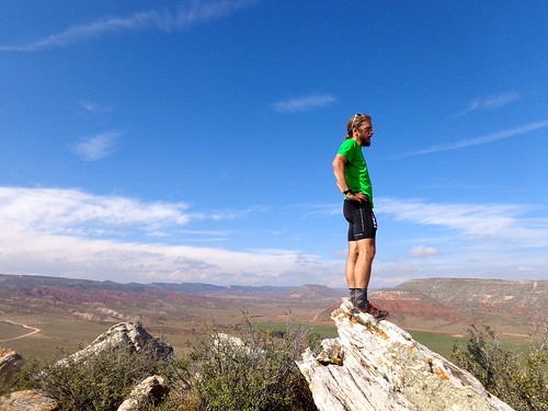
PM: 5 miles (1,800') peakbaggery. Grabbed some peaks with Mike and neighbor Josh on the way back from Wyoming. Had four in the northeast corner of Larimer County planned, but had to bail on the last one due to a lack of time.
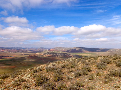
DSC01120
The mesa-like foothills of northern Colorado. All pics: Hinterberg.
DSC01133
Surveying from top Bobcat Mtn.
DSC01101
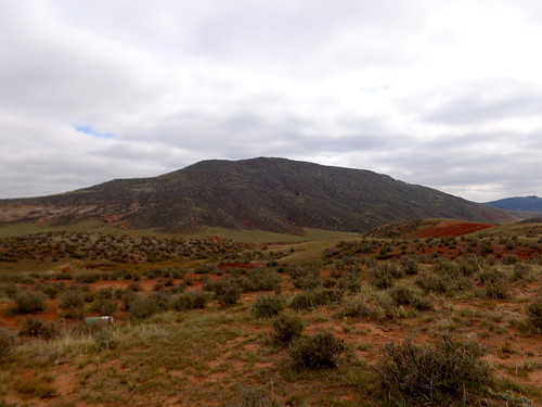
Campbell Mtn from the car. 
Started out with Campbell Mountain, which was easily accessible from the gate at the end of a short road off CO Rd 80. This one did require a gate hop, but there are no signs of human life for miles around, so a pretty stress-free act of encroachment. I was feeling pretty beat up in the leg department from Silent Trails, so just humped my way up while Mike pranced his way to the top way off ahead (apparently he should have been working a little harder at the AM race). The summit of this one is kinda mesa like, with multiple candidates for high point. Tagged 'em all. Up and down in ~40 mins. A good bit of brush to whack through on the hillside.

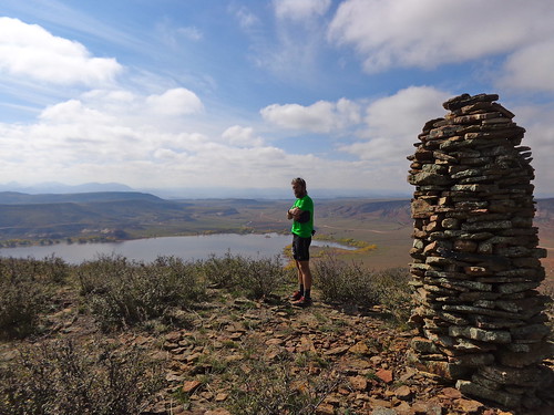
Hopped back in the car and then drove around Park Creek Reservoir to the south, north on CR 19, left on CR21. Parked up directly to the east of 6,380' (which we dubbed the 'Triple Nipple' due to three very prominent cairn stacks) on CR 21, ran quickly across an open meadow (dropping to the ground as a couple of trucks went by), crossed a creek then humped up the southeast ridge following an old use road to near the top. Commanding views of the reservoir and surrounding peaks from the top. Definitely a worthy peak. Back the way we came. Up and down in 35 mins.
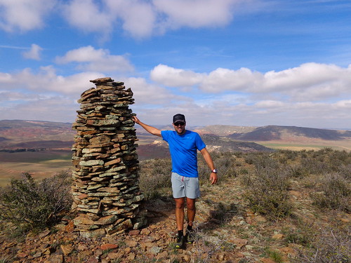
DSC01124
Josh manhandling the summit nip.
DSC01121
DSC01126
Crossing the creek on the way back from the 'Triple Nipple' (6,380' - background)
From the top of 6,380', we contemplated descending to the north and running out to Bobcat Mountain, but the descent looked pretty thick with brush and then the run across the large meadow out to Campbell would have been totally exposed to the road, so we returned to the car, drove a half mile up CR21, parked by a gate and ran full speed for the cover of cottonwood trees by the creek. Humped up from there through mainly grassy terrain, thick with a ton of cactus. Tagged two tops that laid equal claim to the high point, turned around and made our way back quickly, with a final burst of pace to get back across the exposed meadow. Up and down in 30 mins.

Sunday - 2 miles setting up the Rolland Moore 4k T&H course.

Total: 34 miles (6,300')

--------------------------------

Week Ending October 20

Mon - Off 

Tues - 5 miles (1,500') easy. Horsetooth north summit

Weds - 5 miles (1,500') easy. Horsetooth north summit.

Thurs - 5 miles (1,500') easy. Horsetooth north summit. Too early for the sunrise today, but always good to be on a summit early with friends: Lee, Mike, Celeste, Mary B, Marie, Ziggy.
PM: 7 miles (1,700') hill tempo. Mustered just enough energy and motivation for an evening run up Towers. Started at an easy effort and then ratcheted a bit on the second half. Worked harder than I would have liked for a 33.5 min summit, but that's just the state of play right now with my fitness.

Fri - Off

Sat - 2 miles (500') hiking/baggery. Dana was out of town for the weekend, so the kids got to go hiking with their Old Man. Had three peaks lined up for this morning, but a bridge was out by the Poudre water filtration plant for the intended route up 6,823', so we moved onto the next. Bonner Peak is a prominent bump in the northern foothills and has commanding views of Grey Rock among other nearby peaks from the top. Bonner Springs Rd is signed as private, but it gives access to public lands. Not quite sure what the status of Bonner Peak itself is, but we didn't have to jump any fences or pretend not to see any posted signs. From our little pull-off, there was a trail essentially all the way to the rocky summit. Super easy to get and a great little peak. Back in the car down Bonner Springs Rd to Grey Rock Rd. Took that left until we were just northeast of 6,622'. Parked up and then scampered across a meadow to a barbed fence. Alistair point blank refused to go over the fence ... and our day was done. One out of three ain't bad with a 2.75 year old and 7 year old in tow.

Sun - 2 miles (600') hiking/baggery. I had heard that Stove Prairie Rd had re-opened, so we headed out that way to try and get 7,515', which lies just north of the impressive and dominating Ethel Mountain and Stove Prairie Landing. I was wrong on Stove Prairie Rd, which has a huge washout that hasn't yet been repaired just south of the Buckhorn Narrows. Turned around and drove the long drive out to Rist Canyon to try our luck there. Rist Canyon Rd is in decent shape and passable all the way up to Stove Prairie Landing. Headed north from there to the benchmark before the drop into the Poudre (road is closed soon thereafter, BTW). Hoofed through High Park burn terrain and got the summit with relative ease, just as big flakes started coming down. Alistair wanted nothing to do with 7,697', so we called it good after admiring Ethel Mountain for a while. Mike and I got Ethel two winters ago by traveling through fairly dense forest. Unfortunately that was all consumed in the High Park Fire, but somehow the rocky pinnacle looks even more impressive now that it is fully exposed. Lots of mitigation work has been done up here with acres of mulch laid down.

Total: 26 miles (7,300')

Just trundling along here. Really not at all ready to get back into anything remotely structured at this point. I feel like I still need down time to recover from the summer (and indeed the past four years), so that'll be the agenda for at least the next few weeks.

Wednesday, October 16, 2013

Silent Trails 2013

All pics: Mike Hinterberg
The Silent Trails 10 mile race up in the Happy Jack area east of Laramie Wyoming is a race worth doing. Fitness be damned.

This year's race marked the 12th year since a crash on Hwy 287 between Laramie and Fort Collins resulted in the death of eight talented guys, basically the entire University of Wyoming cross country team, at the hands of a drunk driver. Laramie is a small, close-knit college town and the accident had a profound effect on nearly everyone in the community. The Silent Trails race commemorates the eight who died that day, while also serving as a reminder to be thankful for the health and ability that we have as runners to be out enjoying a run in a beautiful place at a beautiful time of year.

For 2013 the entry fee had been dropped to $5 and the focus kept squarely on enjoying, running and reflecting. Per Dan Rodesevich, the new RD:
Hereafter, most aspects of the race will remain the same: We'll always gather on the morning of the second Saturday in October to run the course that Cowboys and Cowgirls became so familiar with while running for Wyoming. Given that the only reward that Wyoming runners expected to receive after completing the circuit in training was a drink of lukewarm water and words of encouragement from Coach Sanchez, I want to keep to a minimum the trappings of tokenism that have crept into most other races. I intend to offer few awards, few prizes, few souvenirs, and a rock-bottom entry fee. On the other hand, camaraderie and mirth we'll continue to have in abundance.
Perfect.

Despite the fine fall weather being enjoyed in the tropical climbs of Fort Collins and Laramie, somehow the Happy Jack area had managed to hold onto the 8-12 inches of snow that had come down two days prior. This provided once again for the expected, nay, demanded adverse running conditions so associated with the Silent Trails race.
Hinterberg enjoying a hot beverage post race.
UW XC alum and Horsecow jog a few to warm up.
At the early morning carpool rendez-vous at Vern's it was great to see such a big turnout from the Fort Collins trail running community, with close to 30 of us ready to convoy north on the hour-long trip to Laramie. True to form, the weather turned to crap as soon as we crossed the Wyoming border. Not the usual howling winds, but we did manage to go from a nice sunny fall morning in Fort Collins to a complete sock-in on the High Plains. Nonetheless, 30 minutes later at 7,000 feet in Laramie things looked good again: no snow on the ground, no winds, and wait was that a ray of sunshine? At 8,000 feet by the Lincoln Memorial, however, the story was once again reversed: proper snow on the ground and more dense fog.

The fog would clear, but the snow would be a pain in the arse.

As always, there were a bunch of former UW cross country runners there ready to race - Dirty Dawgs, I believe they call themselves - among other talented runners who perhaps don't take things quite as seriously these days. From the off, I was surprised to find the pace in the lead pack quite manageable so actually gave thought to racing this thing with a proper effort, but I knew I was horrendously out of shape, so stuck to the plan of getting out and enjoying a hard run without totally grinding myself into the Wyoming dirt, err, snow. By the creek crossing at mile three, I was sitting in fourth in a chase pack of four or five guys behind a lead pack of three who were now 10 meters off the front.

On the run up to the staging point for 'Death Crotch Hill' I geared it down and let everyone in the pack get ahead of me, keeping the effort levels firmly in check. We bunched again going up Death Crotch, with Horsecow Lonac setting a particularly shameful pace off the front, and then split apart going over the top and into the energy-sapping snow drifts. Nik Deininger, who I'd beaten handily last time I raced him at the Pilot Hill 25k back in June when I was fit and ready to get started on my summer of Grand Slam racing, took off not to be seen again. Horsecow fell off the back, while Ragan was hanging tough a few meters behind me, and another guy I didn't recognize was a few meters off the front but still in view.

Ragan and I worked together to bring back fifth-place guy, and then with a mile or two left to race, after jogging as a pack of three for 10 minutes or so, I caught a glimpse of Scott Foley through the trees. Now Scott is a talented former Boise State XC runner. I beat him last year at Pilot Hill after his monumental blow up on the sand flats coming home, before being properly smoked by him at a local 5k road race a month or two later. True to form today, he was completely blowing up through the latter stages of the 10 mile distance, again reminding me that the definition of a long-distance race is entirely subjective. For me, 10 miles is a sprint, for other much more talented guys it might be the longest race of their season. Either way, Scott was clearly done racing, so I took the small rush of seeing a runner come back late in the race as an opportunity to break up my little pack of three to avoid what was looking like it would either be a three-way hand holding finish or some kind of horrendous sprint to the line. I was keen to avoid both scenarios.

The injection of pace was enough to get around Scott, enough to drop the former fifth place guy, but not enough to drop Ragan. Having never been beaten by Ragan - in our many encounters - I was motivated for a bit to try and hold him off, but I simply didn't have anything left in the tank on this day. Ragan dropped me with consummate ease, and so I geared down to a pace that would be sufficient to maintain fifth and cruised into the finish for yet another satisfying romp around the woods of the Medicine Bow National Forest on the second Saturday of October.

Mary Boyts and Cat Speights - inspirations both - getting it done in Wyoming. 
I ended up running seven minutes slower than last year. Some of that was definitely the snow on the ground - versus race-day snowfall and no accumulation last year - but most of it was a singular lack of fitness. I have not been this unfit in quite some time. But that's okay. It's the off season, I need the rest, and I'll get back into it when I feel ready. And that ain't now. In the meantime, I'll continue to be thankful for the gift of running and in particular the gift of running through the woods on snowy fall days.

Thanks as always to Perry, Dan and all of the High Plains Harriers who, quite simply, understand the fundamentals of what running is all about: camaraderie and mirth. I hope to share in the Wyoming mirth and camaraderie for many more years to come.

Mike mixing it up with the top ladies. 

Tuesday, October 8, 2013

Week Ending October 6

Mon - 5 miles (1,500') easy. Horsetooth north summit.

Tues - 3 miles track. Last day of the summer Tuesday Night Track series was, as always, celebrated with a fun relay carnival. Workout was 800 open, then 800, 400, 200 & 100 relays. As was the case last week, I felt absolutely terrible aerobically and not much better physically. Four-person relay teams for the 8-4-2-1.

Picked up the baton in second as the anchor in the 800, with Justin Liddle way off the front in first and Mike H a good bit back in third. Not feeling especially motivated to run hard, I cruised the first lap taking periodic looks over my shoulder to check on Mike who appeared to be closing quickly. By the last bend on the second lap he was on my shoulder ready to kick me down. Normally this would be a no contest as Mike has far superior sprinting speed than I do, but he'd worked hard to get on my shoulder so I figured I might have a chance. Half way down the home straight, I'd given up a couple of meters, and egged on by others I decided to give it a shot just as Mike was gearing down. With five meters to go, I was on Mike's shoulder and it looked like it was going to come down to a lean. We dipped into the line, both falling and scoring some nice track rash. Consensus had it that I out-leaned Mike by a greying beard hair. For the 400, I received the baton in second or third, two or three seconds ahead of Ruth - a D1 (Baylor) sprinter (and fellow Brit) - and ended up trailing her by five meters at the next exchange. To say that I was smoked would be an understatement. The 200 and 100 weren't much better. Looking forward now to the real work of the Tuesday Morning Cemetery workouts, beginning next month, where I'll look to claw back some fitness before beginning the 100-mile training cycle all over again in January.

Weds - 5 miles (1,500') easy. Horsetooth north summit.

Thurs - 5 miles (1,500') easy with the Thursday morning crew - Mike, Lee, Celeste, Ziggy and Slusher - for another beautiful sunrise over the plains.

Fri - Off

Sat - AM: 3.5 miles (2,000') peak-baggery. 5,934', 5,930', 6,176'. Did a bit of early morning 'peak cleaning' on some nearby, but tricky peaks that require exposed periods of 'not being on public property,' or - as Scott likes to put it: 'light trespassing.' Best done under cover of darkness in my experience. Unnamed 5,934' is in fact the closest ranked peak to my house, but requires such blatant trespassing in plain view of 38e - a busy road around the south end of the reservoir - that I've been putting it off and off and off. For this morning I had a very short window before Alistair's soccer game, so I had to keep things local and easy. For those familiar with the area, 5,934' is the high point on the hogbacks on the southeast side of Horsetooth Reservoir. I parked at a pull-off on 38e and then basically hoofed it up the hillside as quickly as possible, tagging the high point (right next to a large antenna), then getting out of dodge just as the pre-dawn was beginning to break. Up and down in 25 minutes. Glad to have that one out of the way.

The next peak that needed cleaning up was 5,930', which sits to the north of Goat Hill (Larimer County's lowest ranked peak) on the other side of Hwy 287 to the east of the turn-off for Hwy 14 and the Poudre Canyon. Parked up at Ted's Place, crossed 287, shimmied around the closed KOA campsite gate and headed straight for the cliff band below the peak, jumping one barbed fence in the process, and working hard to get out of sight of the road as quickly as possible. Once above the cliff band, there was a small gully to negotiate, and then it was a straight shot for the summit with nice views east out to the plains. Came down via a small drainage along the barbed fence line, keeping me out of sight of the road nearly the whole way back to the KOA gate. Booked it across 287, jumped in the car and sped off for the easternmost and lowest ranked peak in the Poudre Canyon: 6,176'. 45 mins RT.

For 6,176' I parked up at a pull-off to the southwest of the peak and made my way up towards the saddle, noting that the land was marked as state land trust, and deciding halfway up to cut directly for the summit on steep terrain rather than waste time hitting the saddle. The wind was blowing hard on the grassy summit, so I didn't linger long, taking a few seconds to check out the look up the Poudre before descending steeply on the southeast slopes heading in a straight line for the car. 40 mins RT.

PM: 16 miles (2,000') easy marking the Blue Sky Marathon course. Phew, I think this is the longest I've run since Wasatch and towards the end there I was doubtful I would actually make it back to the trailhead. It's going to be rough for sure when I decide to get back into some training. Thankfully, I have little motivation to do so right now.

Sun - Off. Great day RD'ing the sixth running of the Blue Sky Marathon. Lots of smiling faces, with just a fantastic day for running, racing and hanging out. Very rewarding.

Total: 37.5 miles (8,500') 

Another week with little to no focus. Had fun grabbing a couple of peaks that have been taunting me for months - nay years - with their proximity and difficulty of access. Now those ones are crossed off the list, I can focus on the Cache La Poudre and clearing the long list of peaks up our very own 'Wild and Scenic' river. But before that happens, Mike and I will be looking to bag a few of Larimer County's northeasterly peaks on the way back from the Silent Trails 10 miler up in Wyoming this Saturday. Carpool spots available if you want to join in the fun. Predicting a Personal Worst at Silent Trails.

Speaking of fun, the Chubby Cheeks committee sat down this weekend at the O'Slushers house post Blue Sky to discuss dates for the fourth - yes fourth - annual running of the Chubster. For those unfamiliar with El Chubbo Grande, it's one of three races that make up the Front Range Grand Slam of Fat Asses. With the fate of the other two races currently in jeopardy thanks to flood- and budget-related woes, this could serve as The Championship event for 2013/14 - perhaps the deepest field ever assembled .... yawn. Anyway, I am happy to announce that after much back and forthing - and lobbying - the date of Dec 7 has been chosen as the golden day. As always, I'll be hosting from my house and we'll be offering four distances: The Big Boy 50k, the Marathon, the Junior Varsity 20 Miler, and the Bad Boi Create Your Own Course and Distance. Flagging will be light to non-existent this year after getting a slap on the wrist last year from the Powers That Be for being overzealous on the flag-hanging front. Bring a map.

Looking a little further afield, Pete and I will be working with the state and county to settle on some dates for next year's Gnarful trail racing series. We're looking at May 10 for Quad Rock, not sure for Black Squirrel (not Tour de Fat weekend this time around), and also not sure yet for Blue Sky, with the addition of a Towers 10k somewhere in the midst of all that uncertainty. So, we'll have a 10k, a half marathon, a marathon and a 50 miler to offer. We're giving serious consideration to the creation of Gnar Wo/Man award for the runner(s) that score the fastest cumulative times across the series. More to come on that soon.  

Tuesday, October 1, 2013

Week Ending September 29

Mon - Off

Tues - 4.5 miles track. Workout was 800 open, 2 x 800, 4 x 400, 4 x 300. Worked harder than I would have liked from some pretty mediocre splits. Ran relay with Lee, pacing with speedsters Leora and Ruth. Amazed at how unfit I feel right now.

Weds - Off

Thurs - 5 miles (1,500') easy. Sunrise on Horsetooth. Yes please. Mike, Lee, Scott, Celeste and Ziggy. Sore calves from the track on Tuesday. Blimey!
It was a little parky on top, but the views - as always - were totally worth it.  All pics: Hinterberg.
Celeste and Ziggy (the WΓΌnderDog).
Scott Slusher says: "Gooooood Morning, Fort Collins!"

Fri - Off.

Sat - 13 miles (3,500') peakbaggery. So good to be off the racing treadmill and out 'running' what and where I want. I had a short window before having to referee Alistair's soccer game at 11:00, so I decided on a couple of local peaks near Lory State Park that I was yet to get due to private property concerns - among other things.

Started from the Well Gulch TH and headed up to Westridge via Timber. After a right on Westridge I took the 'backdoor' park service road north, before cutting due west for the target peaks. Had to hop a couple of gates from here and also hug a fenceline to avoid detection from a couple of ranch properties to the south, before finding an old access road that ran essentially all the way up to the top of unnamed 7,521' on its southeast summit ridge. The views from the open summit were stellar, with particularly open - and unique - looks down Redstone Canyon and an especially good look at the south-north Horsetooth ridgeline, with a killer angle on Horsetooth Rock's northwest exposure. From the top of 7,521', the morning's other target, 7,660' was clearly visible and it looked like the line would take me through a couple of burn areas from last year's massive High Park Fire.

The going was decent - aided by barren firescapes - until the 'saddle' between the two summits, after which the south-facing grunt up 7,660' became pretty arduous thanks to heavy brush and tricky terrain. Views from the top of this one were decent but certainly inferior to the looks from 7,521'. After some brief wandering on the grassy summit to make sure I'd tagged all the candidates for the peak's high point, I retraced back to the car, making it home with enough time to eat breakfast and get a shower before donning the referee's cap. A good morning and a fine start to the LoJ season: 105 down, 150 to go.

Sun - 14.5 miles (4,900') peakbaggery. Sheep Mountain, UN: 7,430', 7,432', 7,612', 6,485'. Whacking away in the prickly Northern Colorado underbrush is not everybody's idea of fun, in fact it can be a struggle to round up partners for these outings, so with Stefanovic transplanted to the east coast I'm down to basically one solid and reliable 'shwhacking partner: Hinterberg. He was off galavanting on the Western Slope celebrating his anniversary or something, leaving me partnerless. Fortunately, Abby stepped up to the plate and agreed to keep me company in a section of Larimer County that I really don't know that well, but should, agreeing to meet me at JJs at a ridiculously early hour for a trip up the Cache La Podure.

Highway 14 up the Poudre Canyon was open for business, apparently unaffected by the deluge from the week prior, and so with the Big Thompson (and hence Estes Park/RMNP) completely shut down, the decision on where to bag peaks was an easy one. In the Poudre Park Quad alone there are 25 ranked peaks to be had, so it was about time I started making some inroads. We started with Sheep Mountain just west of The Narrows from a pull-off a quarter mile east of the Narrows campground, just as dawn was getting ready to break. The hoof up to Sheep was quite straightforward and made all the easier thanks to the High Park Fire having taken care of much of the underbrush. Views of the Pingree Park section of the Mummies were sensational, with a light coating of white adding a nice early-fall contrast. From Sheep we took quite some time getting our bearings, both of us totally turned around by the snaking nature of the Poudre - our main landmark - but eventually figuring out that we needed to be heading north for 7,430', which was clearly visible from Sheep. Again, the going was very good over to 7,430' and we were on the open summit in no time.    

From 7,430, the original plan was to head back down to the river, find a safe place to cross and then grab 7,305' and 7,900'. Once down, I really didn't like the look of the Poudre and the volume of water coming through the main channel. After scouting a half mile of the northern banks looking for a place to cross, we decided to play it safe and run back to the car and just focus on a couple more peaks on the north side of the road/river. We drove upriver a few miles to the Kelley Flats area, parking up and hopping on FR168 which headed in the general direction of 7,432'. We ran that as far as reasonable and then cut cross country for the summit, an aesthetically pleasing and mounded protrusion of granite. This was the only summit of the morning that required any kind of scrambling. Again, the river played tricks with navigational efficiency from the top, but we eventually figured out where the next peak (7,612') was, deciding to cut cross country through a thicket of mountain mahogany on the mountain's western slopes to get there - eschewing a lengthier trail/road approach via the northwest ridge. Good views again of the Mummies from the top, and then we were off down a wooded gully to the east of the main ridge, eventually picking up a trail at the bottom which led us back to FR168 and eventually the car.

Thanks to no major navigational mishaps and relatively open terrain, time was still on our side as we headed back to the Fort east along Hwy 14, so we decided to stop at Hewlett Gulch to pick up a final gimme peak, 6,485', which was an easy cross country walk-up direct from the trailhead. Five peaks on the morning and seven on the weekend. It's good to be back.

Plenty of map checks this morning. All pics: Abby MP.
Looking southwest from peak 4 up the Bennet Creek drainage towards the Mummies.   
Peak 5. A smirk or a grin? Not sure.
Total: 37 miles (9,900')

Really enjoyed being back among the local peaks this week. More of the same for the foreseeable future, although the weekend upcoming will be taken up with getting ready for Sunday's Bluesky Marathon. Slots still available.