Tues - Noon: 5 miles (1,000') easy. Waterfall loop. Couple of miles with Aaron.
PM: 7 miles track. 1.5 mile warm up with the last couple of laps a little quicker to test the waters post Leadville. Things felt okay so I decided to give the workout a decent effort. On tap was 800 open, followed by 4(800/100 float/300/400 jog). Warmed up with the 800 open (3:01) then 2:39, :57, 2:36, :57, 2:37, :57, 2:40, :55.
Weds - PM: 6.5 miles (1,600') easy. Jogged up for a north Horsetooth summit. Rock trail up, Audra/Southridge down. Totally flat.
Thurs - AM: 12 miles (5,000') mountains. Mike and I parked up at the RMNP Alpine Visitor Center then jogged down the Old Fall River Road to tag Marmot Point (11,909'), a ranked (and named) bump of no more than 400 feet of prominence from its nearest saddle. From there we picked up game trails to Chapin Creek and then hopped on the climbing trail that contours under Mount Chapin. When that petered out at Chapin Pass, we were forced into a couple of miles of talus/tundra sidehilling on a 12,000' - 12,500' contour under Chiquita and Ypsilon to the connecting ridge between Desolation Peaks and Ypsilon. We followed that ridge up to the west summit of Desolation Peaks (12,918'), picking up point 12,768' along the way.
As we were enjoying the views from the west summit, I started to get a tingling feeling of electricity in the air. As I relayed this information to Mike, he mentioned that a few of my hair strands were standing on end too. However, the skies did not look particularly malicious, so we foolishly ignored the warning we'd been handed and started the process of connecting the west and east summits of Desolation via the scrambly east/west ridge. Then, BOOM, out of seemingly nowhere a lightening strike as close as I've ever heard one. I didn't see the strike, but it sounded like it was right over our heads. Panicked, Mike and I scrambled off the ridge and found a talus-rock cave to hide in. It started hailing and the thunder/lightening kept coming, so we crouched for a good 40 minutes before we decided things were safe again.
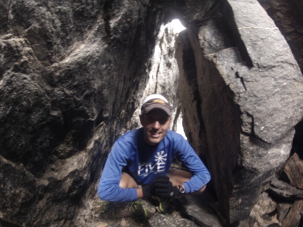 | |||
| Cave dweller. |
Original plans called for a summit of the heavily forested 'nutcracker,' a ranked Larimer peak (10,855'), but my nuts were already cracked from the heavy bushwhacking getting off Desolation, so I made the call to head back up the valley towards the car. We followed Chapin Creek up the valley a ways before picking up a drainage coming off Marmot Point, which we tracked through the woods (with mercifully good game trails) up into the alpine before rounding off with a tag of point 12,005' (a higher put unranked sister to Marmot Point). Mike insisted on a goosey gander around the kitsch-filled visitors center before we took off, and lo and behold it was full of tat.
 |
| West and East Desolation Peaks above and to the right of me. All pics: Hinterberg. |
 |
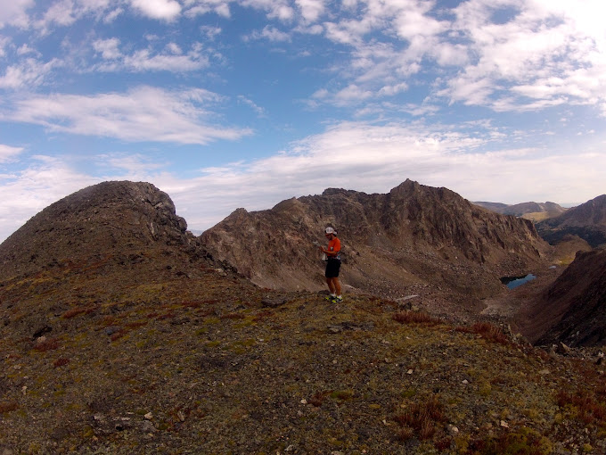
| Rowe Mountain back right, with Fairchild and the connecting ridge to Ypsilon in the right foreground. Desolation Peaks obscured by my head. |
 |
| Summit shot. |
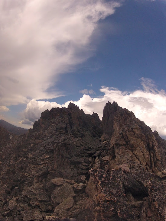 |
| East Desolation from East/West connecting ridge. |
 |
| Chapin Creek/Poudre Valley |
 |
| Backside of Chapin, Chiquita, Ypsilon and Desolation from slopes of Marmot Point. |
Fri - 7 miles (1,700') easy. Jogged up to the Horsetooth south summit.
---------------------------------------------------------------------------
January: 330 miles (45,200')
February: 445 miles (58,500')
March: 501.5 (79,600')
April: 430 (66,800')
May: 387.5 (70,700')
June: 297.5 (48,500')
July: 369 (71,100')
August: 330.5 (67,100')
Total: 3,091 miles (507,500')
Avg: 386 miles (63,438')
---------------------------------------------------------------------------
2012 Summits (129):
.......................................
Horsetooth (7,255') (58 - Sep 1)
.......................................
Mount Elbert (14,443')
Longs Peak (2) (14,259')
Mount Belford (2) (14,197')
Mount Oxford (14,153')
Missouri Mountain (14,067')
Pacific Peak (13,950')
Emerald Peak (13,904')
Crystal Peak (13,852')
Atlantic Peak (13,841')
Iowa Peak (13,831')
Hagues Peak (2) (13,571')
Ypsilon Mountain (13,514')
Fairchild Mountain (13,502')
Mummy Mountain (13,425')
McHenrys Peak (13,327')
Pecks Peak (13,277')
Whitney Peak (13,271')
Powell Peak (13,208')
Taylor Peak (13,153')
Mount Chiquita (13,069')
West Mount Sheridan (12,952')
East Desolation Peak (12,949')
West Desolation Peak (12,918')
Hallet Peak (12,713')
Otis Peak (12,486')
Mount Chapin (12,454')
Flattop Mtn (12,324')
Marmot Point W(12,005')
Marmot Point E (11,909')
Twin Sisters (11,420')
Mount Baldy (11,068')
Hidden Peak (10,992') (2)
Lookout Mountain (10,626')
Storm Mountain (9,918')
Lily Mountain (9,786')
Crosier Mountain (9,250') (4)
Pilot Hill (8,829')
Mount Ethel (8,471')
8,415' (Leila Peak)
Buckhorn Mountain (8,341')
8,310'
Round Mountain (8,250') (4)
Palisade Mountain (8,225')
8,194' (Giant Boulder Point)
Alexander Mountain (8,144')
Spruce Mountain (7,781')
Sullivan Stump (7,778')
7,725'
7,567'
Green Ridge (7,402')
Green Mountain (7,335')
7,260' (Ziggy Point)
7,178'
7,098' (Poll Mtn range)
Table Mountain (7,074')
Arthurs Rock (6,780') (5)
Milner Mountain (6,893')
5,773' or 'Aggie Peak'
5,740' (Hwy 34 B4 Narrows) (1)
5,740' (Off Masonville Rd) (2)
Reservoir Ridge (5,735')
Goat Hill (5,604')
Aitxuri (1,551 meters)
Aizkorri (1,528 meters)
Aratz (1,443 meters)
----------------------------------------------------------------------------
Sat - AM: 15.5 miles (6,400') mountains. Flattop (12,324'), Hallet (12,713'), Otis (12,486'), Taylor (13,153'), Powell (13,208'), McHenrys (13,327'). Met Tony early at the Bear Lake trailhead for what was intentioned as a full Glacier Gorge traverse - an uber-classic RMNP loop that runs the rim of Glacier Gorge, picking up 11 peaks along the way, including Longs - the monarch of the northern Front Range. I had a good bit of familiarity with the route through the first four peaks and also with McHenrys and Longs, but not so much with Chiefs Head and Pagoda, the headwall peaks. I hadn't seen the techie crux sections from Powell to McHenrys and from Chiefs Head to Pagoda, so they were weighing on my mind a bit as we got going, especially Pagoda's west ridge which is considered by most to be a very airy 5.6/5.7. Without protection there's no way I'd take that on, but Tony had beta on a low-class-V sneak on the south face of the ridge. I guess I was dubious about the sneak, as there was simply no beta on it anywhere that I could find, but I told myself I'd at least take a look.
The ascent from Bear Lake went as quickly as it always seems to, and before you could say 'my god those aspen are turning early,' we were above the trees and working into a bit of a breeze, albeit a pretty tame one by Flattop standards. Anyone who's been on Flattop knows that it's not really a mountain in the true sense of the word, but for whatever reason it is named and popular - probably more for the route options available from the plateau than for any aesthetic reasons (and also its relative proximity to the Bear Lake TH). Nonetheless, I was sure to tag the summit boulder (ahem!), before getting started with the meat of the route with a quick ascent of Hallet. Tony got a step on me up Hallet, tagging it a minute, maybe two before me, and he was off before I got there. It was clear he was on a mission, so I didn't bother hanging around either, hoping that I could hang on to his coattails. While I consider myself a decent enough talus negotiator, I couldn't match Tony on the descent off Hallet, so I soon resigned myself to a solo morning in the mountains.
I was heartened to see that I was still within a couple of minutes of Tony off the summit of Otis, a close neighbor to Hallet that offers killer views of the Gorge, Chaos Canyon and Loch Vale (if you take the time to stop and look). The run to Taylor is always a grind, and I once again dipped too low by essentially hitting the rim above Andrews Glacier rather than staying a little further west and maybe 80 feet higher. Not a big deal, but maybe two or three minutes, if you care about such things. I also managed to misdirect to the east a bit after Andrews by being drawn in by false summit 12,829', an unnamed rim bump. I soon realized my error and straightened for Taylor, seeing Tony up on the summit ridge a few hundred feet above.
After Taylor comes Powell, which was to be my first virgin summit of the morning, so I took a few minutes to enjoy the new-to-me vista before heading south in search of the scree gulley that I knew would hook me into McHenrys Notch. I found the gulley immediately, but doubted that it was the right one. I hit it anyway and was relieved to find the cliff bands (easily traversed) that circled back to the base of the Notch a couple hundred feet below the summit of Powell. Looking up at the McHenrys side of the Notch, I was relieved to see what looked like a very straightforward climb. And indeed it was. There may have been a class V move in there somewhere, but it was mainly class IV slabs with surprisingly low exposure (given how vertical the Notch looks from afar). I was up above the Notch in no time, and then it was just a question of negotiating a couple of ledges to the right and a couple more hundred feet of scrambling for the summit. The descent off McHenrys to Stoneman Pass went way quicker than the last time I was up there. And then my engine stalled.
Up on the ledges of Stoneman, I kept cliffing out in search of the line onto Chiefs Head. Backtracking after a second unsuccessful search for the route, I bumped into Joel Wolpert (who was there to film Tony but got to the pass too late), and pretty much felt my desire to continue fade. I looked up at Chiefs Head and all of a sudden the 1,000 feet of relief looked like an insurmountable 3,000 feet. Joel decided that he wasn't going to be able to catch Tony and said he was heading back down the Gorge. Content with six peaks on the morning (and still dubious about the Pagoda route), I stepped in behind Joel, tripping and stumbling my way back down to Bear Lake on legs that were all of a sudden leaden and more than ready to be done.
We were back at the trailhead in a little over five and a half hours, and I have to say I was pretty shocked to see Tony roll in not long after in a time of 6:17 - easily a new standard for the route. Turns out the Pagoda sneak did go. I probably won't get another crack at this until next summer at the earliest, but now that I know the line can be done safely without gear I'll be more committed mentally from the get go. Although not fully successful, this was still a great morning in the mountains.
Splits:
Flattop: 0:59
Hallet: 1:09
Otis: 1:27
Taylor: 2:05
Powell: 2:35
McHenrys: 3:05
Sun - Noon: 1 mile (600') hiking. Took the kids up the Big Thompson a ways and had a picnic at a bend in the river known as Sleepy Hollow. Alistair wanted to do some exploring, so we set off up the steep slopes of the canyon for a ridgeline 500 feet above the river (hard work and somewhat nervy with your daughter in a pack on your back.) Stopped for another picnic at the top and then downclimbed on some pretty sketchy rock that cliffed out on us twice.
PM: 6.5 miles (1,600') easy. A nice late afternoon summit of Horsetooth (north) with Alex. Visibility was way better than it's been in months. Saw Pikes 100 miles to the south for the first time since spring.
Total: 67.5 miles (19,700')
I need to start running some road miles to get ready for UROC, but it's so difficult at this time of year in Colorado. Roads are so much easier to deal with in the winter.


.png)


Read the Mummy Report, and it reminded me of my lightning scare there. Just a few clouds in the sky, but tingling and hair standing on end. It seems that storm build incredibly fast on that range. Glad to hear you two made it out safe for more fun.
ReplyDeleteCheers,
Elijah
Loved the Mummy story, especially the part where you spurned the lesson learned and headed up again toward still-gray skies. Summits do that to a guy, eh?
ReplyDeleteAlistair looking strong in this month's Trail Runner Mag. Much better form than his Dad. Glad you didn't get fried into the Mummies.
ReplyDeleteLoveed reading this thank you
ReplyDelete