When you're sitting atop a scree-filled, 13,000 foot pass at four in the morning after 85 miles of grueling mountain running and you lose your shoe down a cliffed-off scree slope - with 15 miles of brutal running ahead of you - what in God's name do you do? You look at your pacer in disbelief, that's what you do. Without hesitation, Scott took off his right shoe and told me to put it on. In that brief second, I learned a lesson. A lesson about friendship, self sacrifice and absurdity. Just one second out of the 99,791 mind-blowing seconds I spent running in the San Juans this weekend, but a second of my life I will never forget.
There were many other lessons learned and re-learned this weekend, and while I don't have the time or eloquence to recount them all, I can safely state that the peaks, passes and waterways of the San Juan Mountains stripped me to my core and offered a glimpse inside. I saw some good stuff and I saw some bad stuff, but I think I came out the other end in a better place than I started. And mine is just one story among the 150 journeys that began at 6:00 on Friday morning.
 The calm before the storm. Scott, myself and Darcy. All photos: Brendan Trimboli. More here.

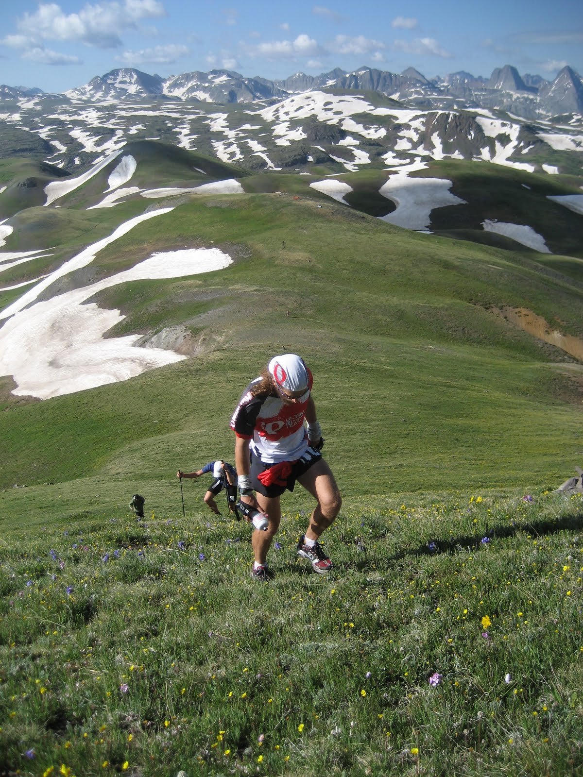
Joe and Karl contemplate the next 30 hours.

The madness begins.
This year was a late snow year, which meant that many of the high passes and basins on the Hardrock course were still buried. The first real taste came in the Grouse-American Basin off Handies, a 14,000' peak. The climb was tough, really tough, but the snow in the basin below was worse: Soft, punchy and unpredictable.
Until this point, 37 or 38 miles in, I had successfully worked through a couple of solid snow sections up on Green Mountain and Buffalo Boy Ridge with Jared Campbell, an experienced Hardrocker (and defending champion) who I was more than happy to be following through the sketchy course markings.


 Up and over Green Mountain with Jared Campbell. All Green Mountain Photos: Dan Goding.
We pulled into Maggie aid station together at mile 15 running in fifth and sixth. On the climb out of Maggie to Cataract Lake, we caught up to Dakota Jones who at 20 years of age was probably the youngest runner in the field. His words of advice as I made to go by him belied his age.
"Nick, we need to get to Ouray at mile 60 feeling like we've been moving way too slowly. Run with me!"
There and then, Dakota may have saved my race. I immediately tucked in behind and slowed to a trot. Jared soon caught up and we jogged as a threesome along the beautiful trails of the Continental Divide at 12,000 feet, crossing the numerous creeks that would ultimately tumble into the Rio Grande and spill into the Gulf of Mexico.
From the Pole Creek aid station (19) we continued as a team, tracking the creek, and route finding together before hitting a beautiful and highly runnable ribbon of trail for a glorious stretch of high-alpine cruising. We split up a bit before hitting the carpeted trail down to the Sherman aid alongside the roaring drainage coming down from Cataract Lake. I lost Dakota ahead and Jared behind, so enjoyed the descent to Sherman alone. Things felt okay. While my legs weren't enjoying the steeper pitches on the descent, clearly not recovered from Western States, I was still eating well and had decent energy.
There was a good vibe at the Sherman aid. I took a few minutes to eat part of a quesadilla and switch out a few bits and pieces, before setting out on the grinder road up to the Handies trailhead. I caught glimpses of Dakota as I jogged my way up. With Danny Levy still in Sherman as I left, this meant I was now running in fourth place - not that I really cared. With 70 some miles and who knows how much vertical relief left to cover, my only concern here was that I was running the road convincingly, at a pace that felt sustainable, and on a stomach that was still agreeable to caloric intake.
It was an unusually hot day I was beginning to realize, so I upped my liquid consumption. At the Burrows Park water cache Dan Brillon helped me fill my bottles, reminding me to go easy on the climb up Handies. More sage words of advice. Below treeline, the climb was actually very pleasant. Steep in places, moderate in others and surprisingly runnable as the mood dictated. Once out of the trees, however, the grunt was on. Mercifully, the skies looked clear.
The race opened up before me as the trees receded into the background. A slow-moving, hands-on-hips Joe Grant was being caught by Dakota who looked to have found some good energy. I figured they were four to five minutes ahead of me in the slow-motion cat and mouse game that is the Hardrock 100. By the summit, Joe and I were grunting it out together. We didn't say a word to each other. Too much effort.
A bomber descent to Sloan Lake, followed by the snow-filled ascent to American-Grouse pass was cause for tumbles, deep post-holing and a few shin rakes on hidden jagged rocks. I wasn't having much fun. Joe and I stuck together through here, dipping our bottles from the abundant run-off under the blazing sun. Finally we hit the pass and it was a beautiful, beautiful cruiser descent down the drainage to the Grouse Gulch aid station (41).
Joe and I must have been visible from a ways up the drainage, as we would hear the cowbells from the aid station long before we got there. I got a change of socks for the dry climb up to Engineer pass at Grouch and felt like I'd been given a new pair of feet. The two or three minutes it took to unload the junk from my shoes, dry my feet and adorn them with mercifully dry socks were perhaps the best-spent minutes of my day.
I picked up my first pacer, Brendan Trimboli, and with a renewed pep in my stride went about fulfilling my pre-race plan of running the first half of the Engineer climb.
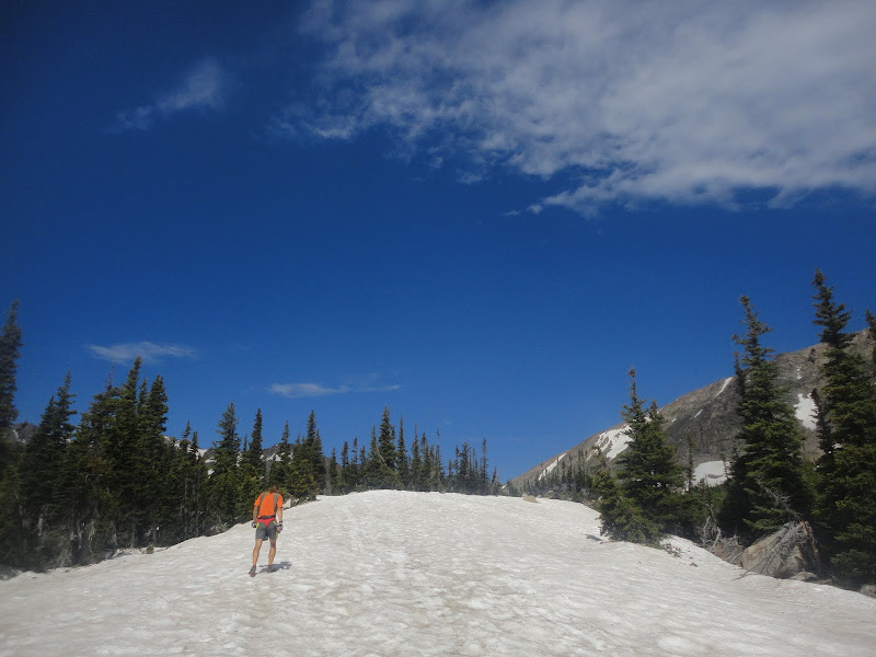
 Dry socks. You have no idea!
 Within a mile, I had run myself into second place. I gave Joe a slap on the ass as I went by and he reciprocated. Dakota was apparently in a rough spot as we passed, saying his wheels were coming off. Brendan and I did what we could to encourage Dakota to hang in there and keep consuming calories, but low points in 100-mile races tend to be very introspective. Dakota grunted.
 Catching Dakota early on Engineer
I had driven the Engineer road with Joe and Pete a few days prior, and had made note of a big switchback in the road about halfway up. My plan was to run there before dropping into full-on hike mode. However, I think it was about there that I caught sight of Julien in the lead, multiple switchbacks ahead, so I decided to forge out a little more running, despite the thinning air and steepening grade. Finally, Brendan reminded me that there was no need to be a hero and I regained my senses.
My stomach was beginning to knot up.
 Hike mode.
  A switchback up on D with awesome views behind.
To this point the gels had been going down just fine and my energy levels had been largely perky. But as we approached the top of Engineer Pass, I was beginning to sense revolt from within. Gels were now being forced down, and the half-hour countdown to the next one always seemed to be on fast-forward.
 Coming down off Engineer.
 Coming off Engineer at 'Oh Point,' we were soon at the aid station and the first thing I asked for was Tums. They had some. Awesome. I chewed a couple and things felt like they might settle down a bit, but the thought of gels was still a stomach churner. The loss of altitude on the long, cruiser descent down Bear Creek into Ouray also helped ease things, but from this point on I never truly recovered my stomach.
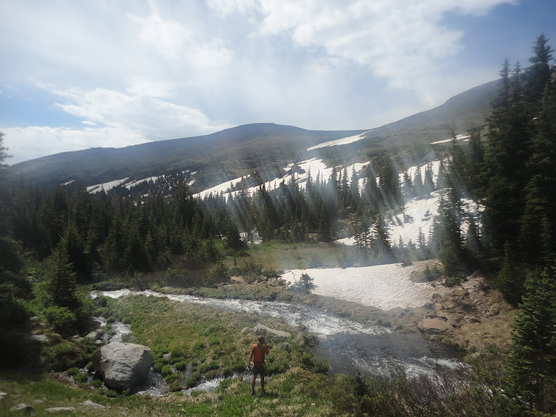
Despite my stomach worries, Brendan and I were rolling really well on the six or seven miles of majestic trail into Ouray. This must be some of the best trail I have ever run. Bear Creek was roaring anywhere from 100 to 300 feet below us as we progressed down the canyon, and only gathered steam as we waded through the numerous creeks that fed it. Truly dramatic stuff!
And then we hit Uncompahgre Gorge, with the town of Ouray opening up before us a thousand feet below. I was tired, groggy and kind of sickly, but you just don't see stuff like this every day.

 One of the sketchier water crossings.
Ouray came and Ouray went. I got some solids down and felt marginally better, but I knew what was coming.

 Dropping into Ouray
 Pre-race, I had planned on running the long grind up Camp Bird Road, but coming into Ouray I had convinced myself that this was a terrible plan. By the time we hit the road, my mind was firmly in the hike camp. Regardless of grade, I told myself, I was hiking the full 5,000'+ to Virginius Pass. As it turned out, I guilted myself into running the shallower grades, but it was all token stuff. Dakota and Troy caught to within a switchback or two near the top, and this actually turned out to be a blessing as there were unmarked forks in the road which they guided us through.
 The hike fest up Camp Bird Road.
Dakota and I arrived at the Governor aid station within seconds of each other and we took a pew together, getting down some potato soup and other bits and pieces that sounded appetizing, while commiserating on our shared fates. As I would for the remainder of the run, I filled one bottle with water and one with coke (now my main source of energy).

The 100-mile stare in full effect at Governor.
Brendan and I followed Dakota and Troy's lights all the way up to Virginius Pass, after flicking them on shortly after leaving Governor. More snow, super sketchy side hills and then we were there at the fabled three-pitch climb up the chute to the pass. It was buried in snow, but the snow was good. We were easily able to kick steps into the soft upper, and while the going was slow, it felt totally under control. Roch Horton and his crew had fixed a rope for the final pitch and so we grabbed it and hauled our asses up to the pass.
Ahh cowbells and pierogies. What can you say about the guys up on the notch at Virginius Pass? They were heroes for me on Friday night. I had seen the lightening show on the pass as I was coming up Camp Bird Road and feared for their safety. However, when we got there they were stoic and more concerned about getting me and Dakota fed and on our way than anything else. The fried pierogies and broth were the best things I consumed all run.


Best aid station in the world. Krogers Kanteen.
Roch explained the digits down to Telluride: five miles and 4,500 feet of descent, with some super sketch snow traversing up high. That didn't sound like a whole bunch of fun. But at Hardrock you have to accept your fate and keep plugging away - it's the only way. The guys had actually carved out some nice ledges through the snow, so it wasn't as bad as it otherwise would have been. The steep scree-like descents killed my quads, but once we got down into the trees and onto the cruiser trails into Telluride the running became bearable again.
Okay, 30 miles to go. Really? Ughh.
I thanked Brendan as we entered Telluride. I'm not the most talkative guy during these ordeals, and Brendan was happy to accompany me in silence for however many hours it was that it took us to hump it from Grouse to Telluride. He had words of encouragement, some gentle prodding when needed, and - like Dakota - an appreciation for the mountains that belies his young age. Brendan will run well in Leadville next month.
I ate too much too quickly in Telluride.
Scott and I ran at a solid pace out of town on the rolling Bridal Veil Falls road, but as soon as we started grunting up on the re-route to Oscar's Pass, I really started losing the handle on my stomach. I have never puked in a race, but I desperately wanted to puke as we marched on up. I told Scott that calories were not an option right now.
 Consuming calories in Telluride.

Joe's version of the 100-mile stare (Telluride).
"Keep drinking, keep the stomach open. We'll try a gel chew at 75 minutes out of Telluride!"
I wanted to tell Scott to shut up and leave me alone, but I knew he was right. I grunted some kind of agreement and descended back into my world of self-pity, all the while taking small sips of coke or water (making sure that Scott was hearing me open and close my bottles).
And then 75 minutes came, and I had to eat. Scott gave me a chew and told me to put it in my cheek and let it dissolve. I obeyed. And then I ate another, and another. It took me an hour to finish six chews and 250 calories. It was something, and 250 more calories than I would have gotten down if I had been by myself. And we still weren't at the pass. Sweet baby Jesus! Why are these climbs so unforgiving?
We made a right off the jeep road and found ourselves negotiating some kind of swampy, snowy mess. It was dark out and the flagging was tough to pick out, however, I could make out the skyline of the pass above contrasted against the starry night. It still looked like a ridiculously long way up to the pass. One foot in front of the other. Oh, there are some lights up there on the ridge. Must be Dakota.
Finally we gained the ridge and hit the pass. The switchbacks coming down the other side were strewn with talus, so we hiked, and then picked our way across some snow banks, before finally hitting some solid dirt that would lead us down into the Putnam aid. I was scared to ask Scott what lay ahead for fear of the inevitable answer. He didn't sugar-coat it.
"We've got to get up Grant Swamp Pass, which is steeper and longer than the push up to Virginius, and without a rope."
We followed Dakota and Troy's lights up Grant Swamp, maybe ten minutes ahead. As advertized, the final push to the pass was brutal. There was no snow, just wet, cold scree. This would make the ascent way harder. I have no idea what the grade is going up Grant Swamp, but it felt near vertical and took forever. We dropped off the other side through more nasty scree and then stopped to empty our shoes. It was four in the morning. My shoe slipped from my hand and I watched as it tumbled down the scree toward the cliff. After 15 meters, we lost sight of the shoe in the dark.
Scott gave me his shoe. I was appalled. There was no way I was going to let him run the last 15 miles of gnarl with one shoe. I told him there was a chance that the shoe might not have toppled over the edge. Scott put his shoe back on and eased his way down the scree on his ass ever so gently. This was absurd. I saw him stop 20 meters down. It looked like he was fishing around for something and then he started easing his way back up. My shoe had caught in some vegetation right on the cliff edge. It was a freaking miracle. We had four Iso Seeks, one for each of our feet. The race was back on.
Well sort of. As dawn began to break, we turned off our lights and trudged on through the marsh. Finally, we hit some glorious trail on a bench over the South Mineral River and the running felt good. As we descended into the KT aid station (89), Scott pointed out the last climb of the day on the other side of the river. It looked completely brutal, but by this point I expected no less. We rolled into KT and to our surprise Dakota was just leaving. Hmm.
I ate my first gel in 25 miles. I gagged, but kept it down. I ate some soup and then mustered up the energy for one last effort. I knew Scott wanted to get after it, see if we could catch Dakota. I complied. We waded the river, headed into the trees and began a super steep climb up the first of three sections to the final pass of the day. We ran everything that was runnable and hiked hard. And then we came out of the trees into a large hillside meadow. No Dakota. Really? Wow! The last vestiges of will power were sucked right out of me then and there and I threw in the towel.
Third it was.
 Stud Muffin.
The final two grunts to the top of Putnam-Cataract ridge just about did me in. I had nothing. And it was so steep. One foot in front of the other. Somehow we gained the ridge, dropped off and descended back into the trees to the final aid station of the day. Victoria Funk, a trail running friend from Fort Collins, was there with cow bells. Friendly faces are good when you are at the depths of your being. I gave Victoria a kiss on the cheek and got my ass out of there. Six more miles.
The trail back into town was at a beautiful cruiser grade, but also happened to be littered with nasty rocks. Despicable. We finally hit the river, crossed uneventfully, and made our way back into town on the last two miles of the course.
Never, ever has a finish line looked so good. This was one hell of a journey.
 Hats off to Julien and Dakota!
 Really?


.png)


